Where Is Choquequirao and How to Visit Peru's Last Inca City Before the Crowds Arrive
Deep in the Apurímac region of southeastern Peru, perched on a mountain ridge at 3,050 meters above sea level, the Inca citadel of Choquequirao remains one of the last great archaeological sites you can visit without sharing it with hundreds of other tourists. Often called the "sister of Machu Picchu," Choquequirao is actually larger, more remote, and in many ways more impressive than its famous cousin. The catch is that getting there requires a multi-day trek through one of the deepest canyons in the world.
That difficulty of access is precisely what makes Choquequirao special. While Machu Picchu receives over 1.5 million visitors per year, Choquequirao sees fewer than 30 people on most days and sometimes none at all. For trekkers, history enthusiasts, and anyone who wants to experience an Inca ruin the way early explorers did, surrounded by silence and mist rather than tour groups and selfie sticks, Choquequirao is the ultimate destination.
This guide covers everything you need to know to plan your trek to Choquequirao in 2026, including how to get there, what to expect on the trail, what to pack, the best time to visit, and what the controversial cable car project could mean for the future of this remarkable site.
Where Exactly Is Choquequirao Located?
Choquequirao sits in the Vilcabamba mountain range, within the Apurímac province of the Cusco region, though it is geographically closer to the Apurímac River than to Cusco city. The ruins occupy a strategic ridge overlooking the Apurímac canyon, one of the deepest canyons in the Americas at over 3,000 meters from rim to river. The site lies at approximately 3,050 meters elevation, though the trek to reach it dips as low as 1,500 meters at the river crossing before climbing steeply back up.
In straight-line distance, Choquequirao is only about 100 kilometers west of Cusco and roughly 50 kilometers southwest of Machu Picchu. However, the rugged terrain and deep canyons between them mean there is no direct road or rail connection. The only way to reach Choquequirao today is on foot, starting from the small town of Cachora in the Apurímac valley.
The Inca chose this location deliberately. Choquequirao was part of the Vilcabamba complex, the last refuge of the Inca resistance against Spanish colonization. Its position on a narrow ridge with steep drops on all sides made it naturally defensible, while its altitude provided a comfortable climate for agriculture and habitation. The site controlled access routes between the highlands and the Amazon lowlands, giving it both strategic and economic importance.
The History of Choquequirao: Cradle of Gold
The name Choquequirao comes from the Quechua words "chuqi" (gold) and "k'iraw" (cradle), meaning "Cradle of Gold." While no significant gold deposits have been found at the site, the name reflects the legendary wealth attributed to the last Inca strongholds in the Vilcabamba region.
Archaeologists believe Choquequirao was built during the reign of the Inca emperor Pachacuti in the mid-15th century and expanded by his successor Túpac Inca Yupanqui. The site served multiple functions: a royal estate, a ceremonial center, an administrative hub for controlling trade routes to the Amazon, and possibly a way station for travelers moving between the highland capital of Cusco and the lowland coca-producing regions.
After the Spanish conquest of Peru in the 1530s, the Vilcabamba region became the last bastion of Inca resistance. Manco Inca and his successors retreated into these mountains and continued to resist Spanish rule until 1572. Whether Choquequirao itself served as a resistance base is debated, but it was certainly part of the network of sites that supported the neo-Inca state.
The Spanish knew of the site's existence but apparently never occupied it. After the fall of Vilcabamba, the jungle slowly reclaimed Choquequirao. It was rediscovered by explorers in the 18th and 19th centuries, with notable expeditions by Hiram Bingham (who also "rediscovered" Machu Picchu) in 1909 and French explorer Eugène de Sartiges in 1834. Serious archaeological excavation did not begin until the late 20th century, and even today, only about 30 to 40 percent of the complex has been fully cleared and restored.
What You Will See at the Ruins
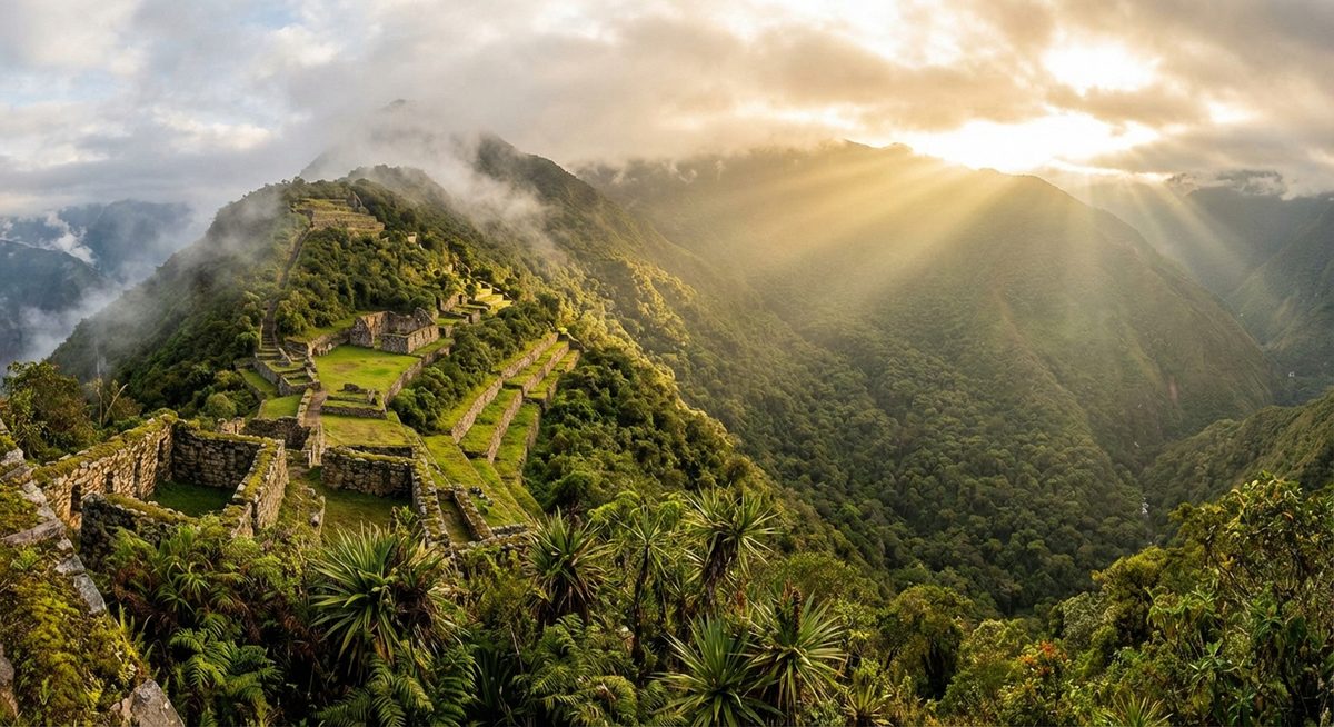
Choquequirao covers approximately 1,800 hectares, making it significantly larger than Machu Picchu. The excavated areas include ceremonial plazas, residential quarters, agricultural terraces, an irrigation system, storage buildings, and a unique set of llama-shaped stone mosaics on the terracing that are found nowhere else in the Inca world.
The main plaza sits at the highest point of the ridge, surrounded by finely cut stone buildings that were likely used for religious ceremonies and elite habitation. The stonework here, while not as refined as the most famous walls at Machu Picchu, is impressive and shows the characteristic Inca technique of fitting irregularly shaped stones together without mortar.
The agricultural terraces cascade down the mountainside in dramatic fashion, and it is on the lower terraces facing the Apurímac canyon that you will find the famous llama mosaics. These are large-scale representations of llamas created by setting white granite stones into the dark stone terrace walls. Scholars believe they had ritualistic significance, possibly related to llama herding or fertility ceremonies. These mosaics are one of the most photographed features of Choquequirao and are entirely unique to this site.
Other notable areas include the Hanan sector (upper town) with its ceremonial buildings, the Hurin sector (lower town) with residential and administrative structures, the Usnu (a ceremonial platform), water channels that demonstrate sophisticated hydraulic engineering, and several outlying building clusters that are still partially covered by vegetation. The sense of discovery is palpable. Unlike Machu Picchu, where every stone has been catalogued and labeled, Choquequirao still feels like a place where secrets remain to be uncovered.
How to Get to Choquequirao: The Trek from Cachora
The standard route to Choquequirao begins in Cachora, a small town in the Apurímac valley about 165 kilometers by road from Cusco. Getting to Cachora is the easy part. You can take a bus from Cusco to Abancay (about five hours) and then a colectivo or taxi from Abancay to Cachora (about two hours), or drive directly from Cusco to Cachora in approximately four to five hours via Curahuasi.
From Cachora, the trek to Choquequirao and back is typically done in four to five days, covering approximately 60 to 65 kilometers round trip. The trail is well-established but demanding, involving significant elevation changes. Here is a day-by-day breakdown of the standard itinerary.
Day 1: Cachora to Chiquisca or Playa Rosalina (6-7 hours)
The trail begins at the Capuliyoc viewpoint above Cachora, at approximately 2,900 meters elevation. On a clear day, you can see Choquequirao in the far distance, a tiny cluster of ruins clinging to a distant ridge. The trail descends steeply through dry scrubland and scattered farms, dropping over 1,400 meters to the Apurímac River. Most trekkers camp at Chiquisca (1,900 meters) or continue down to Playa Rosalina (1,500 meters) near the river. This day is mostly downhill, which sounds easy but is actually punishing on the knees.
Day 2: Playa Rosalina to Choquequirao (7-8 hours)
This is the hardest day. After crossing the Apurímac River on a pedestrian bridge at the canyon floor, the trail climbs relentlessly for approximately 1,500 meters over eight to ten kilometers. The gradient is steep, the sun can be brutal in the morning, and there is limited shade. The climb passes through several ecological zones, from subtropical riverside vegetation to cloud forest and finally to the open grasslands surrounding the ruins. Most trekkers arrive at the Choquequirao campsite in the late afternoon, exhausted but rewarded with their first views of the terraces.
Day 3: Exploring Choquequirao (Full day)
A full day at the ruins is essential. The site is vast, and reaching the llama terraces requires a steep descent from the main complex. Spend the morning exploring the upper sectors, the main plaza, ceremonial buildings, and viewpoints overlooking the canyon. After lunch, make the trek down to the llama mosaics and the lower terraces. The late afternoon light on the ruins is spectacular, and the solitude is extraordinary. You may have the entire site to yourself.
Day 4: Choquequirao to Chiquisca (6-7 hours)
The return trek begins with the steep descent back to the Apurímac River, followed by the grueling climb back up to Chiquisca. Many trekkers underestimate this day because they have already done the route in reverse, but the climb out of the canyon on tired legs is no joke. The campsite at Chiquisca offers basic facilities and a welcome rest.
Day 5: Chiquisca to Cachora (5-6 hours)
The final day involves the long climb back up to the Capuliyoc viewpoint, gaining about 1,000 meters before the last descent into Cachora. By this point, your legs will be thoroughly tested, but the sense of accomplishment is immense. Most trekkers arrive in Cachora by early afternoon, in time to catch transport back to Cusco or Abancay.
Choquequirao vs. Machu Picchu: How Do They Compare?
Comparing Choquequirao to Machu Picchu is inevitable, and both sites have distinct advantages. Machu Picchu is more compact, better restored, and features some of the finest Inca stonework ever created. Its setting between Huayna Picchu and Machu Picchu mountain is iconic and immediately recognizable. The infrastructure is excellent, with train service, buses, guides, and facilities that make it accessible to visitors of all fitness levels.
Choquequirao, by contrast, is larger, wilder, and far less crowded. The experience of arriving on foot after days of trekking, seeing the ruins emerge from the cloud forest, and having them essentially to yourself is something Machu Picchu can no longer offer. The llama mosaics are unique, the setting above the Apurímac canyon is breathtaking, and the sense of genuine exploration is unmatched. The trade-off is the physical difficulty of the trek and the lack of facilities at the site.
If you are considering other remarkable Andean destinations, our guide to whether Rainbow Mountain is worth visiting covers another bucket-list site in the Cusco region. And for more hidden treasures in the Cusco area, read about discovering the hidden gems of Cusco.
The Controversial Cable Car Project
For years, the Peruvian government has been discussing plans to build a cable car (teleférico) from the Apurímac valley directly to Choquequirao, which would reduce the journey from a multi-day trek to a ride of approximately 15 minutes. The project has been approved in principle and has gone through various planning phases, with projected completion dates that have repeatedly been pushed back.
The cable car is deeply controversial. Proponents argue that it would bring much-needed tourism revenue to the impoverished Apurímac region and make a world-class archaeological site accessible to visitors who cannot undertake the strenuous trek. They point to the success of infrastructure investments at other Peruvian sites and the potential for Choquequirao to become a major international destination.
Critics fear that the cable car would destroy exactly what makes Choquequirao special: its remoteness and tranquility. They point to the overcrowding problems at Machu Picchu, where visitor limits have been imposed to prevent further degradation of the site. Environmental concerns about the cable car's impact on the fragile canyon ecosystem are also significant. Some archaeologists worry that a sudden influx of thousands of daily visitors could damage ruins that have barely been excavated.
As of 2026, the cable car has not been built, and the timeline remains uncertain. If you want to experience Choquequirao in its current pristine, uncrowded state, the window may be narrowing. Whether or not the teleférico is ultimately constructed, the trek itself will always remain an option for those who prefer to earn their arrival on foot.
Best Time to Visit Choquequirao
The dry season from May to September offers the best trekking conditions, with clear skies, minimal rain, and excellent visibility. June through August is peak season, when you are most likely to encounter other trekkers on the trail, though "crowded" at Choquequirao means perhaps 20 to 30 people at the ruins on a busy day.
The wet season from November to March brings heavy rainfall that can make the trail muddy and slippery, and the ruins are often shrouded in clouds. However, the wet season also means lush green vegetation, fewer trekkers, and dramatic cloud formations. April and October are transitional months that can offer the best of both worlds: drier trails with green scenery and very few other visitors.
Temperature varies significantly with altitude. At the river crossing (1,500 meters), expect hot, humid conditions during the day. At the ruins and campsites (2,900 to 3,050 meters), nights can be cold, dropping to near freezing between June and August. Pack layers that you can add and remove as the altitude changes throughout each day.
What to Pack for the Choquequirao Trek
Proper preparation is essential for the Choquequirao trek. Unlike the Inca Trail to Machu Picchu, there are no luxury lodges or porter services as standard, though some tour operators offer mule support for carrying gear. Here is what you should bring.
For clothing, pack moisture-wicking base layers, a warm fleece or down jacket for cold nights, a waterproof rain shell, trekking pants, a sun hat, and sturdy broken-in hiking boots with ankle support. Bring at least three pairs of hiking socks. For sleeping, a three-season sleeping bag rated to minus five degrees Celsius is appropriate for dry season travel. A sleeping pad adds comfort on the basic campsite ground.
Essential gear includes trekking poles (your knees will thank you on the steep descents), a headlamp with spare batteries, a water purification system (either tablets, a filter, or a SteriPEN), sunscreen with high SPF, insect repellent, and a basic first-aid kit that includes blister treatment, pain relief, and altitude sickness medication. Bring enough snacks for the full trek, as there are very limited purchasing options along the trail. A few basic shops at campsites sell water and simple supplies at inflated prices.
Do not forget your passport and cash for the entrance fee to Choquequirao, which costs approximately 60 soles for foreign visitors. There are no ATMs anywhere near the trailhead, so withdraw cash in Cusco or Abancay before departing.
Guided Treks vs. Independent Trekking
Unlike the Inca Trail to Machu Picchu, the Choquequirao trek does not require a licensed guide or a permit. You can hike independently if you are an experienced trekker comfortable with route-finding, camping logistics, and carrying your own gear. The trail is generally well-marked, though signage can be sparse in places.
However, hiring a guide or joining an organized trek has significant advantages. Local guides from Cachora know the trail intimately, can arrange mule support to carry heavy gear, set up camps, and prepare meals. This dramatically reduces the physical burden and allows you to focus on the experience rather than logistics. Guided treks typically cost between 300 and 600 USD per person for a four to five day trek, depending on group size and level of service.
Whether you go guided or independent, register at the checkpoint in Cachora before starting the trek. This is a safety measure that ensures authorities know who is on the trail. If you are trekking independently, let someone in Cachora know your planned itinerary and expected return date.
Fitness and Altitude Preparation
The Choquequirao trek is rated as moderate to difficult. The primary challenge is not technical climbing but rather the sheer amount of elevation gain and loss over consecutive days. You will descend and then ascend approximately 1,500 meters in each direction, for a total elevation change of around 6,000 meters over the four to five day trek. Knee joints take the worst beating, particularly on the long descent to the river on day one and the climb out on day four.
Physical preparation should begin at least six to eight weeks before your trek. Focus on cardiovascular fitness through running, cycling, or stair climbing, and strengthen your legs with squats, lunges, and step-ups. If you have access to hilly terrain, practice loaded hiking with a backpack of the weight you expect to carry.
Altitude is less of a concern at Choquequirao than at many other Peruvian treks, as the maximum elevation is only about 3,050 meters. However, if you are arriving directly from sea level, spend at least two to three days acclimatizing in Cusco (3,400 meters) before starting the trek. Most trekkers find that by the time they have spent a few days in Cusco and traveled to Cachora, they are adequately adjusted. For more about planning your Cusco-region visit, see our guide to the top destinations in Peru.
Frequently Asked Questions About Visiting Choquequirao
How difficult is the Choquequirao trek compared to the Inca Trail?
The Choquequirao trek is generally considered more physically demanding than the classic four-day Inca Trail. While the Inca Trail reaches a higher pass (Dead Woman's Pass at 4,215 meters), the Choquequirao trek involves steeper and more prolonged ascents and descents. The total elevation change over the trek is greater, and the terrain in the Apurímac canyon can be relentless. Additionally, the Choquequirao trek typically has less porter support and fewer facilities along the way. That said, the Choquequirao trail does not require the altitude acclimatization needed for higher-altitude treks, and the maximum elevation is modest by Andean standards.
Do I need a permit to trek to Choquequirao?
No permit is required for the Choquequirao trek, unlike the Inca Trail to Machu Picchu which requires advance booking and a licensed guide. You simply pay the entrance fee at the site itself or at the checkpoint. This makes Choquequirao one of the most accessible major treks in Peru in terms of logistics, as you can decide to go on relatively short notice. However, if the cable car is ever completed, a permit system may be introduced to manage visitor numbers.
Is there camping available at Choquequirao?
Yes, there is a designated campsite near the ruins of Choquequirao with flat ground for tents, basic toilet facilities, and a water source. The campsite is free to use with your entrance ticket. Conditions are basic: there are no showers, no electricity, and no food vendors. You must be fully self-sufficient or have arranged a guided trek with cooking support. The campsite fills up very rarely, as visitor numbers remain low. Along the trail, there are also basic campsites at Chiquisca, Playa Rosalina, and Marampata with similar minimal facilities.
Can I connect the Choquequirao trek to Machu Picchu?
Yes, an extended trek of eight to nine days connects Choquequirao to Machu Picchu via the remote Vilcabamba range. This route continues from Choquequirao over high passes, through cloud forest, and eventually joins the Santa Teresa valley before reaching Aguas Calientes. It is one of the most spectacular long-distance treks in South America but is significantly more demanding and remote than either trek done individually. A guide is strongly recommended for this combined route, as some sections are poorly marked and pass through very isolated terrain.
When will the Choquequirao cable car be built?
The cable car project has been discussed and planned since the early 2010s, with several projected completion dates that have all been delayed. As of 2026, construction has not begun on the main infrastructure, and the timeline remains uncertain. Political changes, budget constraints, environmental reviews, and community opposition have all contributed to delays. Some observers believe the cable car may eventually be built within the next decade, while others doubt it will happen at all. If you want to experience Choquequirao in its current unspoiled state, visiting sooner rather than later is advisable regardless of the cable car timeline.
How much does the Choquequirao trek cost in total?
Budget travelers trekking independently can complete the Choquequirao trek for approximately 150 to 250 USD, including transport from Cusco to Cachora and back, the entrance fee (about 60 soles), food, and basic campsite fees. A guided trek with mule support, meals, and equipment typically costs 300 to 600 USD per person depending on group size and operator. Add the cost of any gear you need to purchase or rent in Cusco. Overall, Choquequirao represents excellent value compared to the Inca Trail, which costs a minimum of 600 to 700 USD with required guide and permits.
Is there mobile phone signal on the Choquequirao trek?
Mobile signal is extremely limited on the Choquequirao trail. You may get intermittent reception at the Capuliyoc viewpoint near Cachora and occasionally at higher points along the ridge, but for most of the trek, including the canyon floor and the ruins themselves, there is no signal. Carry a fully charged power bank and consider bringing a satellite communicator or personal locator beacon for emergencies. Inform someone of your itinerary and expected return date before departing.
Can I hire mules or porters for the Choquequirao trek?
Yes, mule support is available and can be arranged through tour operators in Cusco or directly with arrieros (mule drivers) in Cachora. Mules typically carry camping gear, food, and heavy equipment, allowing you to hike with just a daypack. The cost for mule support is approximately 80 to 120 soles per day per mule, including the arriero. This service makes the trek significantly more manageable and is highly recommended for anyone not accustomed to carrying a heavy pack over steep terrain for multiple days.
Choquequirao is one of the last places in Peru where you can experience the scale and grandeur of Inca architecture without the filters of mass tourism. The trek to reach it is challenging, but that challenge is inseparable from the reward. Standing alone on a mountain ridge with nothing but ancient stone walls, cloud forest, and the sound of the Apurímac River far below is an experience that stays with you long after the blisters have healed. Go before the cable car changes everything.